


L'aiguillon-lac du Pontet depuis Valfroide

geranimo
User
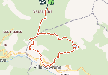

Length
11.6 km

Max alt
2076 m

Uphill gradient
690 m
Km-Effort
21 km

Min alt
1590 m

Downhill gradient
692 m
Boucle
Yes
Creation date :
2019-12-17 22:54:28.218
Updated on :
2020-01-24 00:18:10.353
--
Difficulty : Medium

FREE GPS app for hiking
 SityTrail
IGN / Geographical institutes
SityTrail Plus
The world is yours!
About
Trail On foot of 11.6 km to be discovered at Provence-Alpes-Côte d'Azur, Hautes-Alpes, La Grave. This trail is proposed by geranimo.
Positioning
Country:
France
Region :
Provence-Alpes-Côte d'Azur
Department/Province :
Hautes-Alpes
Municipality :
La Grave
Location:
Unknown
Start:(Dec)
Start:(UTM)
290231 ; 4993780 (32T) N.
Comments